
First Demonstration of Agriculture Height Retrieval With PolInSAR Airborne Data
Por favor, use este identificador para citar o enlazar este ítem:
http://hdl.handle.net/10045/128224


| Título: | First Demonstration of Agriculture Height Retrieval With PolInSAR Airborne Data |
|---|---|
| Autor/es: | Lopez-Sanchez, Juan M. | Hajnsek, Irena | Ballester-Berman, J. David |
| Grupo/s de investigación o GITE: | Señales, Sistemas y Telecomunicación |
| Centro, Departamento o Servicio: | Universidad de Alicante. Departamento de Física, Ingeniería de Sistemas y Teoría de la Señal | Universidad de Alicante. Instituto Universitario de Investigación Informática |
| Palabras clave: | Agriculture | Airborne sensors | Parameter retrieval | Polarimetric SAR interferometry (PolInSAR) | Synthetic aperture radar (SAR) | Vegetation |
| Área/s de conocimiento: | Teoría de la Señal y Comunicaciones |
| Fecha de publicación: | 29-sep-2011 |
| Editor: | IEEE |
| Cita bibliográfica: | IEEE Geoscience and Remote Sensing Letters. 2012, 9(2): 242-246. https://doi.org/10.1109/LGRS.2011.2165272 |
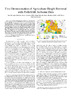
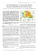
| Resumen: | A set of three quad-pol images acquired at the L-band in interferometric repeat-pass mode by the German Aerospace Center (DLR) with the Experimental SAR (E-SAR) system, in parallel with the AgriSAR2006 campaign, has been used to provide, for the first time with airborne data, a demonstration of the retrieval of vegetation height from agricultural crops by means of polarimetric SAR interferometry (PolInSAR)-based techniques. Despite the low frequency of the data, hence providing a weak response from the vegetation volume in contrast to the ground, accurate estimates of vegetation height at field level have been obtained over winter rape and maize fields. The same procedure does not yield valid estimates for wheat, barley, and sugar beet fields due to a mismatch with the physical model employed in the inversion and to the specific crop condition at the date of acquisition. These results show the value of the information provided by both interferometry and polarimetry for some agriculture monitoring practices. |
| Patrocinador/es: | This work was supported in part by the Spanish Ministry of Science and Innovation (MICINN) and European Union FEDER under Project TEC2008-06764-C02-02 and Grant PR2009-0364 of the National Program of Human Resources Movability, by the University of Alicante under Project GRE08J01, and by Generalitat Valenciana under Projects GV/2009/079 and ACOMP/2010/082. |
| URI: | http://hdl.handle.net/10045/128224 |
| ISSN: | 1545-598X (Print) | 1558-0571 (Online) |
| DOI: | 10.1109/LGRS.2011.2165272 |
| Idioma: | eng |
| Tipo: | info:eu-repo/semantics/article |
| Derechos: | © 2011 IEEE |
| Revisión científica: | si |
| Versión del editor: | https://doi.org/10.1109/LGRS.2011.2165272 |
| Aparece en las colecciones: | INV - SST - Artículos de Revistas |
Archivos en este ítem:
| Archivo | Descripción | Tamaño | Formato | |
|---|---|---|---|---|
 Lopez-Sanchez_etal_2012_IEEE-LGRS_preprint.pdf Lopez-Sanchez_etal_2012_IEEE-LGRS_preprint.pdf | Preprint (acceso abierto) | 14,93 MB | Adobe PDF | Abrir Vista previa |
 Lopez-Sanchez_etal_2012_IEEE-LGRS_final.pdf Lopez-Sanchez_etal_2012_IEEE-LGRS_final.pdf | Versión final (acceso restringido) | 1,02 MB | Adobe PDF | Abrir Solicitar una copia |
 Ver citas en Google Académico
Todos los documentos en RUA están protegidos por derechos de autor. Algunos derechos reservados.